 Penn 1730s

|

|
|

|
back to object record | |
| Notes about Penn's NE Prospect across Coniston Water, 1733 | ||
|
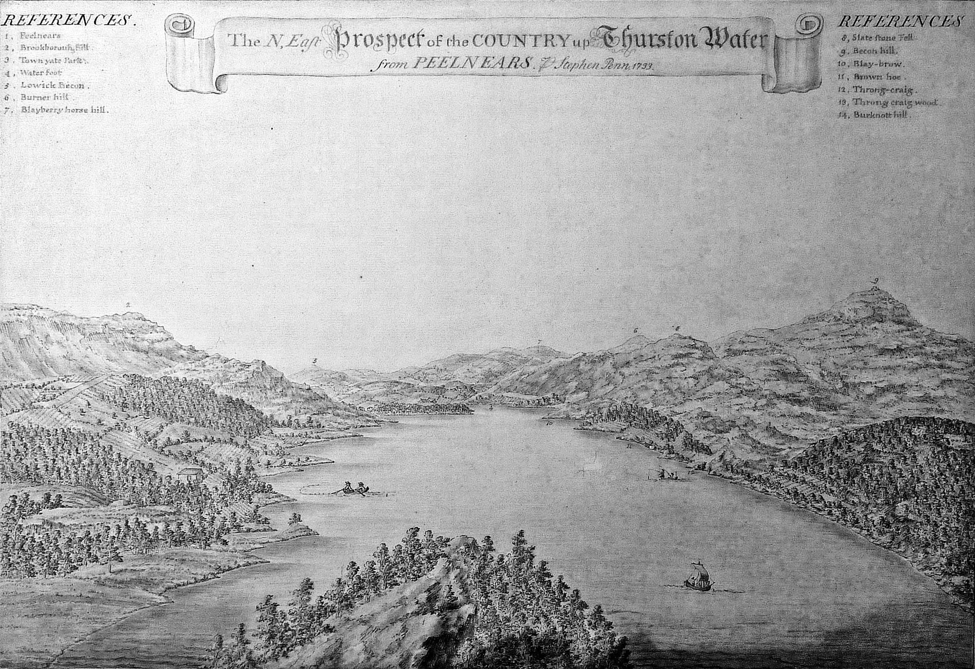
These notes are about the watercolour painting, N East Prospect
of the Country up Thurston Water from Peelnears, by Stephen
Penn, 1733. The item has only been seen in photographic
images, it is in the collection of the Victoria and Albert
Museum, item P3-1941, and they hold the copyright. We are
particularly grateful to have access to this image because the
painting is part of a series of very early outline views.
|
||
References
Coombs, Katherine (curator, paintings, VandA, London): 2010: correspondence with John Tullis |
||
|
||
|
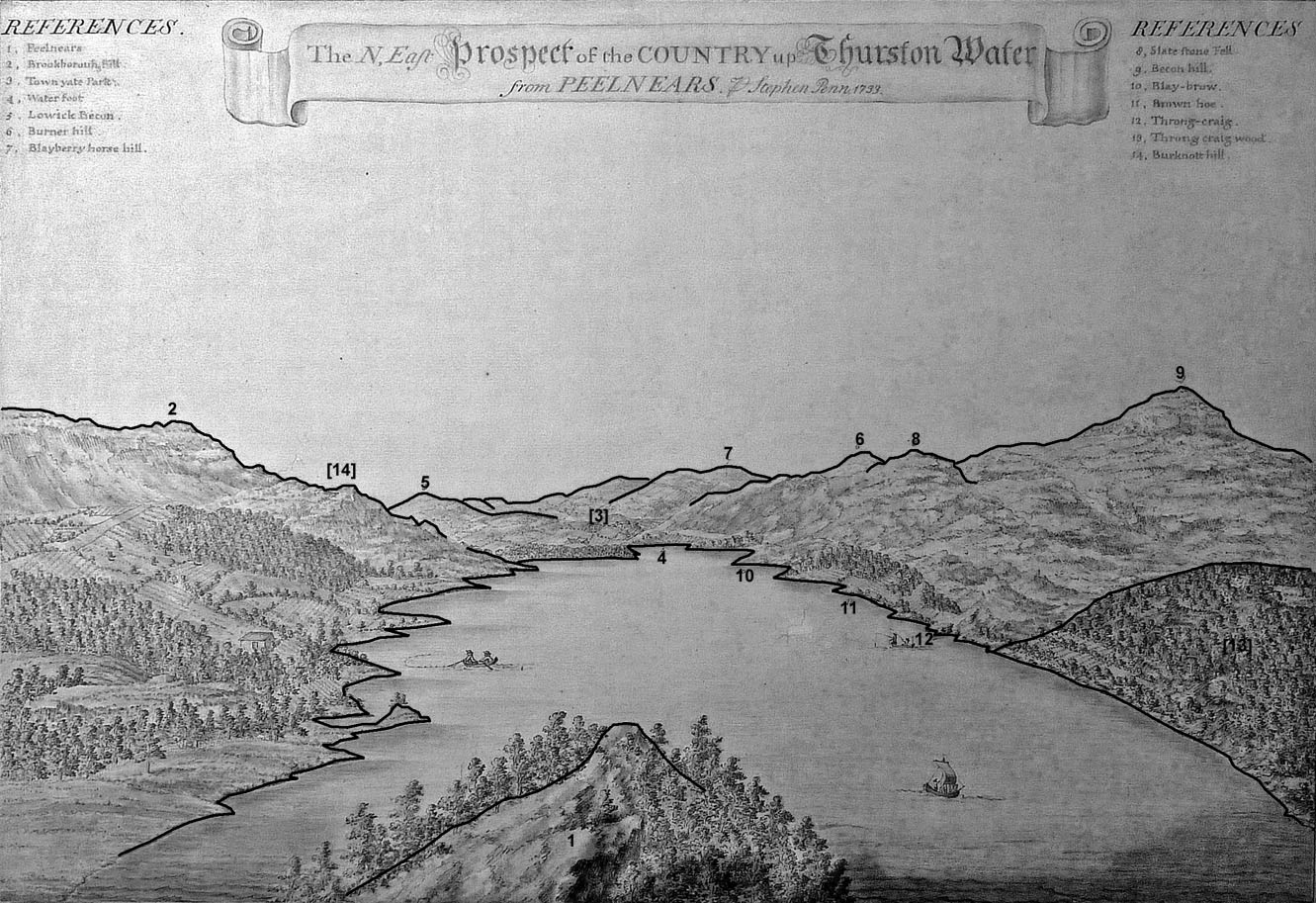
The painting is one of a series of four. Each scene has numbered features in the picture with a list of identifications, making them the precursors of 'outline views'. The place interpretations are ours.
|
||
| Outline View | ||
|
||
Objects in the View |
||
|
The viewpoint is High Peel Near on the eastern shore; this
peninsula was called Peel Ness, a better name, a ness is a
headland. The lake is Coniston Water, Thurston Water being
an older name. The direction of the view is SSW, not NE;
down the lake, not up. Numbered objects in the view can be
identified today, the names a little different. The
identifications list name, civil parish and grid reference.
|
||
|
|
||
| caption |
Painted upper left and right:-
REFERENCES. / 1. Peelnears / 2. Brook[borouh ] Hill 3. Town yate Park / 4. Water foot / 5. Lowick Becon. / 6. Burner hill / 7. Blayberry horse hill / 8. Slate stone Fell / 9. Becon hill / 10. Blay-brow / 11. Brown hoe / 12. Throng-craig / 13. Throng craig wood / 14. Burknott hill. |
|
|
|
||
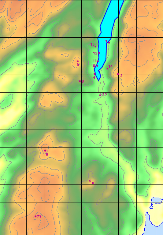
| 1. Peelnears |
High Peel Near, Colton, SD295917.
|
|
|
|
||
| 2. Brookborouh hill |
Brock Barrow, Dunnerdale-with-Seathwaite, SD22029428.
|
|
|
|
||
| 3. Town yate Park |
at Water Yeat?
The number label is not clear on the image I have to work with. |
|
|
|
||
| 4. Water foot |
No trace of a placename Water Foot has been found,
perhaps this is just a descriptive label. It matches Water
End on earlier maps, about SD287900.
|
|
|
|
||
| 5. Lowick becon |
Lowick Beacon, Lowick, SD28648407.
|
|
|
|
||
| 6. Burner hill |
Probably Great Burney, Kirkby Ireleth, SD26088586.
Earlier maps use Burney Hill. |
|
|
|
||
| 7. Blayberry horse hill |
Probably Gunson Height, Kirkby Ireleth, area with summit
at SD25588214. There is a Horse Head on the height.
Note that there is a Bleaberry Haws, Torver, SD264945, which doesn't fit the label. |
|
|
|
||
| 8. Slate stone Fell |
Slatestone Fell, Blawith and Subberthwaite, SD280896.
|
|
|
|
||
| 9. Becon hill |
Beacon, Blawith and Subberthwaite, SD27799068.
|
|
|
|
||
| 10. Blay-brow |
Blea Brows, Blawith and Subberthwaite, SD289904 etc.
|
|
|
|
||
| 11. Brown hoe |
Brown Howe, Blawith and Subberthwaite, SD29049078.
|
|
|
|
||
| 12. Throng-craig |
Thrang Crag, Blawith and Subberthwaite, SD290915
roughly.
This is not found labelled on any map, there is a crag on the OS County Series 25inch sheet Lan 7 3. |
|
|
|
||
| 13. Throng Craig wood |
Thrang Crag Wood, Blawith and Subberthwaite, SD288915
etc.
|
|
|
|
||
| 14. Burknott hill |
Birk Knott, Colton, SD294903.
The number label has not been found on the image I have to work with. |
|
|
These places are located as:-
|
||
|
||
The View Today |
||
|
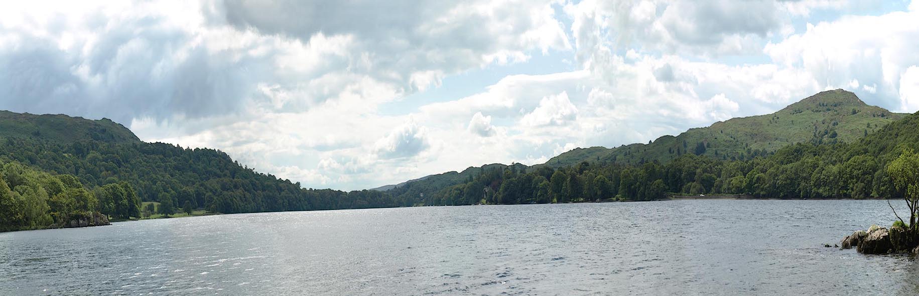
There is no view from the highest part of Peel Near today,
tree planting now obscures the scene, except for glimpses
between the branches and leaves. It is possible to see a
whole view from the shore of the headland, but, to get any
comparison the photograph has vertical exageration about
170%. The view is from SD29499168, 13 August 2010.
|
||
|
||
|
Even standing on a rocky eminence close to the shore, the
view a little confused by bushes, the picture is not like
Stephen Penn's view. He has floated himself above the
headland to get a birds eye view of the lake. Being unable
to levitate we cannot check just what can and cannot be
seen, and remain doubtful about Lowick Beacon, for example,
which isn't visible from lower down. Gunson Height is also
doubtful; note that the wind turbines in this direction are
a helpful guide. We wonder how much has been put in because
his guide said 'over there is ...' rather than 'what you see
is ...'. Only major features like Brock Barrow, Birk Knott,
Beacon on Blawith Fells, and Thrang Crag Wood, are obvious
to the eye; a few other features are recognizable.
|
||
Lakes Guides menu.