 Pennant 1777

|

|
|

|
back to object record | |
| MAP FEATURES | ||
|
These notes are biased toward Westmorland and Cumberland
interest, and might ignore features in other areas.
|
||
|
|
||
|
title
map maker publisher |
Printed upper right:-
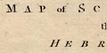
A MAP of SCOTLAND the HEBRIDES and PART of ENGLAND adapted to MR. PENNANT'S Tours Printed bottom left and centre:- J. Bayly sculp. / Published 1st. of May 1777 by Benj, White. |
|
|
|
||
|
orientation
up is N |
The map is printed with North at the top of the
sheet.
|
|
|
|
||
| lat and long scales |
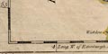
Printed in the borders are scales of latitude and longitude for conical projection; chequered in 10 minute intervals, labelled at degrees. The map includes from about 4d E to 4.5d N, from 52d 50m to 59d 30m N; all of Scotland except the Shetland Isles, and the north part of England down to Derbyshire. Notice that longitude is measured:- Long. W. from Edinburgh as stated on the bottom longitude scale. |
|
|
|
||
|
sea area
sea plain |
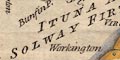
The sea are is plain. Some sea areas are labelled, eg:- ITUNA AEST / SOLWAY FIRTH MORICAMBE AEST [Morecambe Bay, not in the Solway] |
|
|
|
||
|
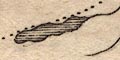
coast line
coast shaded coast tinted foreshore sands |
The coast line is emphasised by shading and tinted blue. Foreshore sands are indicated by dotted areas, for example the Lancashire Sands, Leven Sands, etc. |
|
|
|
||
| rivers |
Some rivers are drawn by a wiggle line tapering upstream.
A few rivers are labelled, eg:-
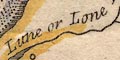
Lune or Lone R Petterell R [labelling the River Eden] |
|
|
|
||
| lakes |
Three of the larger lakes are drawn by an outline with a shaded shore. Other lakes are hinted at at the top of some rivers. Two lakes are labelled:- Congleton Mere [Coniston Water] Winander Mere Other lakes might be recognised, with less certainty, eg:- Derwent Water Ennerdale Water Kentmere Tarn Ullswater |
|
|
|
||
| country |
The country boundary is a dotted line. Each country has a yellow tint along the inside of its border and coast line. The area of northern England is labelled:- MAXIMA CAESARIENSIS which is usually used for the roman province around London. |
|
|
|
||
| county |
The county boundaries are a dotted line. The county areas are labelled, eg:- WESTMORELAND CUMBERLAND |
|
|
|
||
| settlements |
Settlements are marked by a circle, perhaps with
vestigial added elements, differentiated by style of
labelling, perhaps with roman placenames. The map's title
suggests that places of antiquarian interest to Thomas
Pennant have been chosen. The distinction into city, town,
village, is not very meaningful for this map; it would be
helpful to read Thomas Pennant's description of the map, if
there is one.
|
|
| capital |
circle; labelled in upright block caps.
|
|
|
cities
towns |
circle, possibly with added elements; labelled in italic
block caps, eg:-
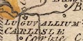
LUGUVALLUM / CARLISLE CALACUM / APPELBY |
|
| towns |
circle; labelled in upright lowercase text, eg:-
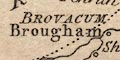
BROVACUM / Brougham Cockermouth Whitehaven |
|
|
towns
villages |
circle; labelled in italic lowercase text, eg:-
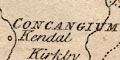
CONCANGIUM / Kendal Kirkby Lonsdale Moresby VOREDA / Penrith |
|
|
|
||
| miscellaneous | ||
|
|
||
|
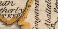
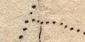
antiquities
roman sites roman wall roman forts |
Hadrian's Wall is marked by a double line from Bowness on Solway, north of Carlisle, then north-east and east across the country. At intervals a square symbol is marked, labelled with the name of a roman fort, eg:- Congavata |
|
| Roman Placenames | ||
|
The following roman placenames are found in the Cumbria area
(reduced to lowercase):-
|
||
Aballaba [square symbol, on the Wall, about Newtown] |
||
Amboglana [square symbol, on the Wall, about Castlesteads] |
||
Aplatorium / Beaucastle [Bewcastle] |
||
Axelodunum [square symbol, on the Wall, about Burgh by Sands] |
||
Brovacum / Brougham |
||
Calacum / Appelby [Appleby] |
||
Concangium / Kendal |
||
Congavata [square symbol, on the Wall, about Carlisle] |
||
Dictis / Ambleside |
||
Gabrosentrum [square symbol, on the Wall, about Drumburgh] |
||
Ituna Aest. / Solway Firth |
||
Luguvallium / Carlisle |
||
Moricambe Aest. [Morecambe Bay] |
||
Olenacum / O. Carlisle [Old Carlisle] |
||
Petriona [square symbol, on the Wall, about Walton] |
||
Tunnocelum [square symbol, on the Wall, about Bowness on Solway] |
||
Virosidum / Wigton (?) |
||
Voreda / Penrith |
||
Verterae / Brough |
||
|
The placenames do NOT all match the more reliable
identifications in:-
|
||
Rivet, A L F & Smith, Colin: 1979: Place-Names of Roman Britain: Batsford (London) |
||
|
The data should not be used for the Old Cumbria Gazetteer
without further research.
|
||
Lakes Guides menu.