 Paterson 1785

|

|
|

|
back to object record | |
| Cumbria Roads | ||
|
Notes are made about roads relevant to Cumbria.
|
||
|
Each page has two strip maps, each with its own page number.
The pages of interest are:-
|
||
|
direct roads:-
|
||
strip map (p.33/34) / London to Edinburgh by Carlisle / From before Gretta Bridge, through Bowes, Durham; then Rear Cross, to beyond Brough, Westmorland. |
||
strip map (p.35/36) / London to Edinburgh by Carlisle / From Appleby, Westmorland; through Penrith to Carlisle, Cumberland. |
||
strip map (p.37/38) / London to Edinburgh by Carlisle / From past Carlisle through Longtown, Cumberland; across the Eden at Longtown into Scotland, through Langholm, etc. |
||
strip map (p.67/68) / London to Skipton etc, continued to Kendal etc / From SE, through Kirkby Lonsdale, Kendal, Ambleside, Westmorland; and into Cumberland at Dunmail Raise. |
||
strip map (p.69/70) / London to Skipton etc, continued to Kendal etc / From beside Thirlmere, through Keswick, Cockermouth, to Whitehaven, and a branch to Workington, Cumberland. |
||
strip map (p.99/100) /London to Carlisle by Coventry and Warrington / From before Preston, to beyond Lancaster, Lancashire. |
||
strip map (p.101/102) / London to Carlisle by Coventry and Warrington / from before Burton, then Kendal, to beyond Shap, Westmorland. |
||
strip map (p.103/104) / London to Carlisle by Coventry and Warrington AND London to ... Manchester etc / From Westmorland; to Penrith, Cumberland. AND the start of a new road. |
||
|
and cross roads:-
|
||
strip map (cross p.5/6) / Newcastle to Carlisle and Whitehaven / From E, Northumberland; through Brampton to past Carlisle, near Hesket Newmarket, Cumberland. |
||
strip map (cross p.7/8) / Newcastle to Carlisle and Whitehaven AND Hull to York / From before Cockermouth to Whitehaven, Cumberland. And the start of a new road. |
||
| MAP FEATURES | ||
|
|
||
|
title cartouche
map maker publisher |
The beginning of each road is printed at its start in a
semicircular cartouche - you might have to go back several
pages to find this title. The cartouche includes the road's
title, where it commences, perhaps some places on the way,
and perhaps the volume and page where it comes of another
road.
On each sheet there is a page header, eg:- 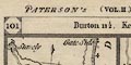
PATERSON'S (VOL.II.) ITINERARY. DIRECT (VOL.II.) ROADS. and a page footer:- Printed for the Proprietor CARINGTON BOWLES, London, 3 Jan. 1785. The double page has a header giving the two page numbers and the distances of successive stages, eg p.35/36:- 35 / Appleby 8, Penrith 14, Carlisle 18. / 36 Appleby being 8 miles from Brough on the previous page, it is then 14 to Penrith, Penrith to Carlisle 18. These figures match the mile numbering on the maps which start again from each town. |
|
|
|
||
|
orientation
north point up is destination |
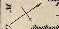
The strip maps are printed with their destination at the top of the page; you see the road laid out before you, but you have to read upwards. Each segment of road, one or more on a strip, has a north point; N-S line, E-W cross line, North marked by a spear point, East marked by a cross. |
|
|
|
||
| scale |
There is no scale line. Estimating from the labelled road
distances the map scales are about:-
1 to 190000 3 miles to 1 inch |
|
|
|
||
|
sea area
sea plain |
Any small area of sea that shows is plain. A sea area
might be labelled, eg:-
IRISH SEA off Whitehaven vol.2 p.8 and vol.2 p.70. |
|
|
|
||
|
coast line
coast form lines |
The coast line is drawn with form lines. |
|
|
|
||
|
rivers
bridges |
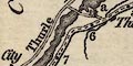
Broader rivers are drawn by a wiggly double line with
stream lines tapering upstream, narrower streams with a
tapering wiggly line. (Do not mistake the Picts Wall for a
river.) The larger rivers might be labelled, eg:-
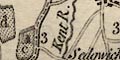
Kent R. [vol.2 p.101 mile 3 etc] Eamont R. [vol.2 p.103 mile 24] Trout Beck[vol.2 p.68 mile 10] Bridges are implied where a road crosses and interrupts a stream. Few are labelled, but see, for example:- Ouse Bridge[vol.2 p.7 mile 22] which might be labelling the locality not the bridge as at:- Eamont Br. [vol.2 p.103 mile 25] Trout Beck Bridge [vol.2 p.68 mile 10] Notice that the Wath Bridge across Thirlmere is clearly delineated. |
|
|
|
||
| lakes |
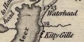
The parts of lakes that are shown, near to the route, are drawn by an outline with from lines. Some are labelled:- Bassenthwaite Water [vol.2 p.69] Derwent Water [vol.2 p.69 mile 12] Tarn Wadling [vol.2 p.36 mile 9] Thurle Mere [vol.2 p.69 mile 8-5] Winander Meer [vol.2 p.68] Other lakes might be recognized, eg:- Bassenthwaite Lake [vol.2 p.7 mile 21-22] Blelham Tarn [vol.2 p.68 mile 12] Cunswick Tarn [vol.2 p.67 mile 2] decoy pond, Lowther [vol.2 p.102 mile 21] Easedale Tarn [vol.2 p.68] Grasmere lake [vol.2 p.68 mile 13-12] Little Langdale Tarn [vol.2 p.68] Loughrigg Tarn [vol.2 p.68] Rydal Water [vol.2 p.68 mile 14-13] Stickle Tarn [vol.2 p.68] (?) Terrybank Tarn [vol.2 p.67 mile 9] (?) |
|
|
|
||
|
relief
hill hachuring |
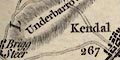
Ups and downs along the roads are shown by hill hachuring. Occasionally hills beside a road are marked. A few hills are labelled, eg:- Binsey [vol.2 p.7 mile 19] Thiefside Fell [vol.2 p.36 mile 7-8] Underbarrow Scar [vol.2 p.67] Mislet Moor [vol.2 p.68 mile 8-10] and the hill on which stands Kendal Castle. But there is no hint of the rise over Shap, or the hills beside the road by Thirlmere. |
|
|
|
||
|
forests
trees |
A forest might be shown by a labelled group of tree
symbols, as at Salcey Forest, Northamptonshire vol.2 p.104,
but there are none in Westmorland or Cumberland.
|
|
|
|
||
| parks |
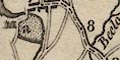
Parks are drawn by an outline of fence palings, the interior dotted. These are labelled by a lowercase letter referring to a list at the foot of the page; examples on p.101/102, at the bottom:- a Dallam Tower, Wilson Esqr.- b Levens Hall & Park, Earl of Suffolk.- c Syzergh Park, Strickland Esqr.- d Brig Steer Park.- e Whinfield Esqr. |
|
|
|
||
| county |
County boundaries are a dot dash line. County areas are
labelled, usually alongside the route, eg:-
WESTMORELAND CUMBERLAND Sometimes the change of county is labelled at the boundary, eg:- 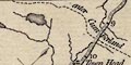
enter Cumberland [vol.2 p.68 mile 10 1/2] |
|
|
|
||
| settlements |
Settlements are marked by blocks or groups of blocks,
perhaps making a street plan at larger places,
differentiated by style of labelling.
|
|
|
cities
distances from London street plan |
blocks on a street plan; labelled in upright block caps,
eg:-
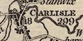
CARLISLE / 299 [vol.2 p.36 mile 18] the figure being the distance from London. |
|
|
towns
distances from London town plans |
group of blocks, perhaps on a street plan; labelled in
upright lowercase text, eg:-
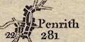
Penrith / 281 [vol.2 p.35 mile 22] Longtown / 308 9vol.2 p.37 mile 82] Kendal / 267 [vol.2 p.101 mile 0] the figure being the distance from London. But it might not be safe to assume that the distance from London is the distance by the route of the strip map, it may by another route.*COMMENT4 A county town is labelled in italic block caps, as:- 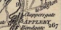
APPLEBY / 267 [vol.2 p.35 mile 10] |
|
|
villages
hamlets |
a block or blocks; labelled in italic lowercase text,
eg:-
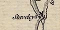
Staveley [vol.2 p.67 mile 5] Natland [vol.2 p.101 mile 2] |
|
| houses |
Great houses, perhaps some not so great, are marked by a
building symbol, which might be labelled directly, eg:-
Wood Hall [vol.2 p.70 NE of Cockermouth] or labelled with a letter referring to text at the foot of the page. For example:- 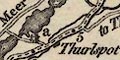
a [vol.2 p.69 mile 6-5] at the bottom:- a Dale Head, Leathes Esqr. ... A mixture of label and reference might be used, eg:- Hill Top / b [vol.2 p.67 mile 3] b Robinson Esqr. |
|
| castles |
building and two towers; labelled as houses, directly or
referring to text at the bottom of the page. Examples:-
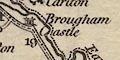
Brougham Castle [vol.2 p.35 mile 19] a / a Naward Castle, Earl of Carlisle [vol.2 p.5 mile 44] |
|
|
|
||
|
roads
road distances |
The road that is the subject of the strip map runs up the centre of the strip clearly drawn by a triple line, bold solid, light dashed, light solid. At mile intervals from the a town is a dot within the dashes labelled with the distance from the town. The numbers count either up from or down to a town, depending on the relative importance of the towns. For example on p.101/102, the Lancaster road north, the count is up from Lancaster ending 10, 11 then Burton, from Burton the count is down, 10, 9, ... 1 to Kendal, then up from Kendal to Penrith. Lesser roads, sometimes just a short branch, sometimes a network of side roads, are drawn by broad or narrow double line, connecting the route of the map to the surrounding settlements. Some side roads are labelled with a destination and perhaps a note that the route off is mapped on another page. Eg:- to Cockermouth p.67 [vol.2 p.101 at Kendal] to Appleby [vol.2 p.101 at Kendal] |
|
|
|
||
| miscellany | ||
|
|
||
| stones |
On the S side of the Lancashire Westmorland border by the
Lancaster to Kendal road, a square symbol is labelled:-
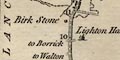
Birk Stone [vol.2 p.101 mile 10-11] |
|
|
|
||
|
antiquities
roman wall roman forts |
A hatched double line marks:-
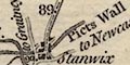
The Picts Wall [vol.2 p.36 mile 90] for example vol.2 p.5 where it is parallel the road. Along or near the wall are symbols for roman forts. |
|
|
|
||
| mosses |
An irregular area west of Longtown is labelled:-
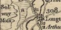
Solway Moss / a [vol.2 p.37 mile 81] at the foot of the page:- a. Land covered by the overflowing of the Solway Moss, in 1771. |
|
Lakes Guides menu.