 Brabant 1902 map

|

|
|
|
item:- JandMN (502_24) image:- © see bottom of page |
click to enlarge |
|
|
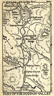
Map, uncoloured lithograph, Part of the Duddon Valley,
Cumberland and Lancashire, scale about 1 inch to 1 mile, by
B C Boulter, published by Methuen and Co, 36 Essex Street,
Strand, London, 1902.
Tipped in opposite p.360 of The English Lakes, by F G Brabant. |
||

|
Brabant 1902 map | |
| inscription:- |
printed bottom left
BCB |
|
| inscription:- |
printed with scale line
Miles |
|
| scale line:- | 4 mile = 100.9 mm | |
| wxh, sheet:- | 9.5x15cm | |
| wxh, map:- | 61x104mm | |
| scale:- | 1 to 64000 ? ( 1 to 63800 from scale line) | |