 Brabant 1902 map

|

|
|
|
item:- JandMN (502_6) image:- © see bottom of page |
click to enlarge |
|
|
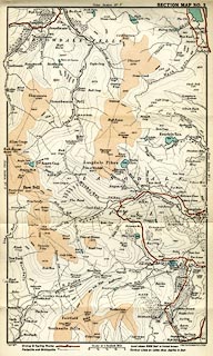
Map, colour lithograph, Longdale and Borrowdale,
Westmorland, scale about 1 inch to 1 mile, by John
Bartholomew, Edinburgh, published by Methuen and Co, 36
Essex Street, Strand, London, 1902.
Tipped in opposite p.94 of The English Lakes, by F G Brabant. |
||

|
Brabant 1902 map | |
| map feature:- | folded & table of symbols (minimal) & up is N & scale line & rivers & lakes & depth soundings & relief & contours & spot heights & layer colouring & woods & settlements & roads | |
| inscription:- |
printed bottom left, right
Copyright / John Bartholomew & Co. Edinr. |
|
| inscription:- |
printed with scale line
Scale of 1 English Mile |
|
| scale line:- | 1 mile = 25.4 mm | |
| wxh, sheet:- | 15.5x30cm | |
| wxh, map:- | 141x234mm | |
| scale:- | 1 to 63000 ? ( 1 to 63360 from scale line) | |