 Brabant 1902 map

|

|
|
|
item:- JandMN (502_1) image:- © see bottom of page |
click to enlarge |
|
|
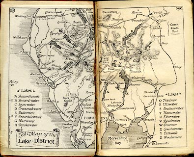
Map, uncoloured lithograph, A Map of the Lake District,
scale about 8 miles to 1 inch, by B C Boulter, published by
Methuen and Co, 36 Essex Street, Strand, London, 1902.
On the front end papers of The English Lakes, by F G Brabant. |
||

|
Brabant 1902 map | |
| map feature:- | scroll cartouche & table of symbols & up is N & scale line (vertical) & sea plain & coast shaded & rivers & lakes & relief & hill hachuring & settlements & roads & railways | |
| inscription:- |
printed upper left, right
BCB / 1902 monogram |
|
| inscription:- |
printed title cartouche, lower left
A Map of the / Lake District |
|
| inscription:- |
printed with scale line
Miles |
|
| scale line:- | 20 miles = 62.9 mm | |
| wxh, sheet:- | 19x15.5cm | |
| wxh, map:- | 170x139mm | |
| scale:- | 1 to 510000 ? (1 to 511715 from scale line) | |