 Green 1910s-20s map

|

|
|
|
item:- Armitt Library : A6482.3 image:- © see bottom of page |
click to enlarge |
|
|
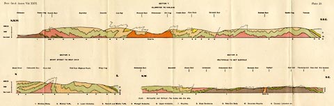
Geological section, colour lithograph, sections Ullswater
to Yarlside, Brant Street to Wray Crag, and Heltondale to
Wet Sleddale, by J Frederick N Green, published in the
Proceeding of the Geologists' Association, vol.26, about
1915.
Illustrating an article, The Structure of the Eastern Part of the Lake District. |
||

|
Green 1910s-20s map | |
| inscription:- |
printed top left, right
Proc. Geol. Asso. Vol.XXVI. / Plate 19. |
|
| wxh, sheet:- | 68.5x21.5cm | |