 Green 1910s-20s map

|

|
|
|
item:- Armitt Library : A6482.2 image:- © see bottom of page |
click to enlarge |
|
|
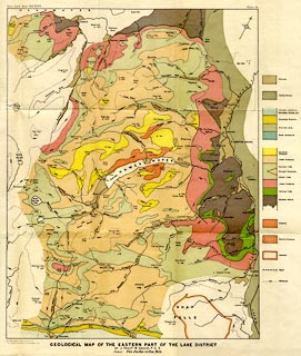
Geological map, colour lithograph, Geological Map of the
Eastern Part of the Lake District, scale about 2 inches to 1
mile, by J Frederick N Green, engraved by The Watford
Engraving Co, 5 Lamb's Conduit Street, Holborn, London,
published in the Proceeding of the Geologists' Association,
vol.26, about 1915.
Folded and tipped in, illustrating an article, The Structure of the Eastern Part of the Lake District; sections printed on another plate. |
||

|
Green 1910s-20s map | |
| map feature:- | folded (3x3) & north point & up is NW & rivers & lakes & relief & contours & spot heights & settlements & geology & stratigraphical column | |
| inscription:- |
printed top left, right
Proc. Geol. Asso. Vol.XXVI. / Plate 18. |
|
| inscription:- |
printed bottom left, centre
THE WATERFORD ENGRAVING Co. Ltd. 5 LAMB'S CONDUIT ST. HOLBORN W.C. / GEOLOGICAL MAP OF THE EASTERN LAKE DISTRICT / BY J. FREDK. N. GREEN, F.G.S. / SCALE : Two Inches = One Mile. |
|
| wxh, sheet:- | 61x59.5cm | |
| wxh, map:- | 399x516 | |