 Cary 1787

|

|
|
|
item:- private collection (288) image:- © see bottom of page |
click to enlarge |
|
|
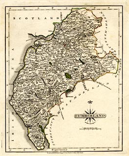
Map, hand coloured engraving, Cumberland, scale about 6.5
miles to 1 inch, by John Cary, 188 Strand, London, 1787, edn
1793.
|
||

|
Cary 1787 | |
| map feature:- | compass rose cartouche & compass rose & up is N & scale line & lat and long scales (rectangular projection?) & sea plain & coast form lines & rivers & lakes & relief & hill hachuring & forests & parks & county & settlements & roads | |
| inscription:- |
printed title cartouche, lower right
CUMBERLAND |
|
| inscription:- |
printed bottom
London : Published Jany. 1st. 1793. by J. Cary, Engraver & Map-seller, Strand. |
|
| inscription:- |
printed with scale line
British Statute Miles 69 1/2 to a Degree. |
|
| scale line:- | 10 miles = 38.0 mm | |
| wxh, sheet:- | 24.5x31cm | |
| wxh, map:- | 211x262mm | |
| scale:- | 1 to 420000 ? (1 to 423512 from the scale line assuming a statute mile) | |