 Walker 1837

|

|
|
|
item:- private collection (287) image:- © see bottom of page |
click to enlarge |
|
|
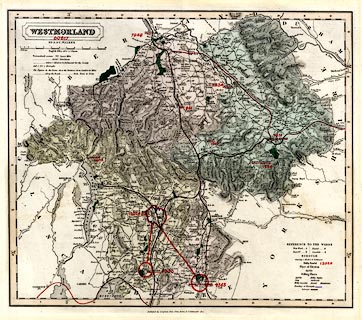
Map, Westmorland, scale about 3 miles to 1 inch, by J and
C Walker, about 1837, published by Longman, Rees, Orme,
Brown, Etc, Paternoster Row, London, 1837, edition about
1860s.
Plate 37 from an atlas. The map is ammended to include - 'Lancaster & Carlisle Raily.' or 'Railroad'; 'Kendal & Windermere Raily.'; 'Nth. Western Raily.' which is the Low Gill and Ingleton branch railway; the South Durham and Lancashire Union Railway; and part of the Eden Valley Railway. Some of the additions are manuscript amendments; the SDandLUR is engraved by a triple line to east of Hartley then by a sinle line which has not been followed correctly by the colourist, the EVR is engraved only to just north of Kirkby Stephen, but the colurist has taken it to Clifton. The map also has manuscript amendments apparently givein population figures. |
||

|
Walker 1837 | |
| map feature:- | plain cartouche & up is N & scale line & lat and long scales & coast shaded & rivers & relief & hill hachuring & woods & forests & parks & county & electoral data & wards (hundreds) & settlements & roads & canals & railways & population data | |
| inscription:- |
printed plain cartouche, upper left
WESTMORLAND / BY J. & C. WALKER |
|
| inscription:- |
printed bottom
Published by Longman, Rees, Orme, Brown, & Co. Paternoster Row. |
|
| scale line:- | 10+1 miles = 92.4 mm | |
| scale:- | 1 to 190000 ? (1 to 191589 from scale line) | |
| wxh, sheet:- | 45.5x36.5cm | |
| wxh, map:- | 376x323mm | |