 Dugdale 1835

|

|
|
|
item:- private collection (285) image:- © see bottom of page |
click to enlarge |
|
|
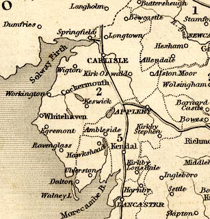
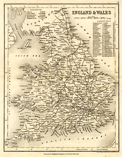
Map, uncoloured engraving, England and Wales, scale about
48 miles to 1 inch, drawn and engraved by J Archer,
Pentonville, London, about 1835.
Published as plate 1 in Curiosities of Great Britain, England and Wales Delineated, by Thomas Dugdale, 1835. |
||

|
Dugdale 1835 | |
| map feature:- | table of symbols & up is N & scale line & lat and long scales (trapezoidal projection? from Greenwich) & sea plain & coast shaded & rivers & lakes & county & table of counties & settlements & roads | |
| inscription:- |
printed upper right
ENGLAND & WALES |
|
| inscription:- |
printed bottom right, centre
Drawn & Engraved by J. Archer, Pentonville, London. / Engraved for Dugdales England and Wales Delineated. |
|
| inscription:- |
printed with scale line
SCALE / Miles |
|
| scale line:- | 100 miles = 53.3 mm | |
| scale:- | 1 to 3000000 ? (1 to 3019407 from scale line) | |
| wxh, sheet:- | 22x27cm | |
| wxh, map:- | 186x239mm | |
|
||