 Dugdale 1835

|

|
|
|
item:- private collection (283) image:- © see bottom of page |
click to enlarge |
|
|
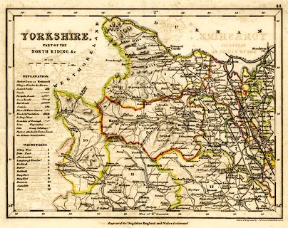
Map, hand coloured engraving, Yorkshire Part of the North
Riding etc, scale about 7.5 miles to 1 inch, drawn and
engraved by J Archer, Pentonville, London, about 1835.
Parts adjacent to Westmorland. Published as plate 44 in Curiosities of Great Britain, England and Wales Delineated, by Thomas Dugdale, 1835. |
||

|
Dugdale 1835 | |
| map feature:- | table of symbols & up is N & scale line & lat and long scales (trapezoidal projection?) & rivers & relief & hill hachuring & parks & county & hundreds (wapontakes) & table of hundreds (wapontakes) & settlements & roads & railways | |
| inscription:- |
printed upper left
YORKSHIRE, / PART OF THE / NORTH RIDING &c |
|
| inscription:- |
printed bottom right, centre
Drawn & Engraved by J. Archer, Pentonville, London. / Engraved for Dugdales England and Wales Delinneated |
|
| inscription:- |
printed with scale line
SCALE |
|
| scale line:- | 10 miles = 34.2 mm | |
| scale:- | 1 to 470000 ? (1 to 470568 from scale liine) | |
| wxh, sheet:- | 25x21cm | |
| wxh, map:- | 236x178mm | |