 Hall 1833

|

|
|
|
item:- private collection (281) image:- © see bottom of page |
click to enlarge |
|
|
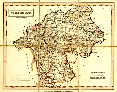
Map, hand coloured engraving, Westmoreland ie
Westmorland, scale about 5 miles to 1 inch, by Sidney Hall,
published by Chapman and Hall, 186 Strand, London, about
1860s.
From the Travelling County Atlas or the New County Atlas by Sidney Hall. |
||

|
Hall 1833 | |
| map feature:- | sectioned for folding & mounted & folded (3x2) & card cover & plain cartouche & north point & scale line & lat and long scales & coast shaded & rivers & lakes & relief & hill hachuring & parks & county & wards (hundreds) & table of wards (hundreds) & settlements & roads & canals | |
| inscription:- |
printed in and below title cartouche, upper left
WESTMORELAND. / ENGRAVED BY S. HALL. |
|
| inscription:- |
embossed cover
WESTMORLAND gold on greens |
|
| inscription:- |
printed bottom
London, Published by Chapman & Hall No.186 Strand March 1832 |
|
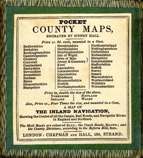
| inscription:- |
printed advert inside cover
POCKET / COOUNTY MAPS, / ENGRAVED BY SIDNEY HALL. / Price 1s. 6d. each, mounted in a Case. / ... |
|
| inscription:- |
printed with scale line
English Miles. |
|
| scale line:- | 10 miles = 48.4 mm | |
| scale:- | 1 to 330000 ? (1 to 332509 from scale line) | |
| wxh, sheet:- | 26.5x21cm | |
| wxh, cover:- | 9.5x11 cm | |
| wxh, map (including gaps):- | 250x199mm | |

|
||
|
||