 Owen-Jones 1885

|

|
|
|
item:- private collection (254) image:- © see bottom of page |
click to enlarge |
|
|
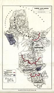
Map, colour lithograph, North Lancashire, New Divisions
of County, scale about 3 miles to 1 inch, by LtCol Robert
Owen-Jones, printed by the Ordnance Survey, Southampton,
Hampshire, 1885.
The map shows the proposed new parliamentary divisions, petty session divisions and parliamentary boroughs; attached sheets list parishes. Printed for the Redistribution of Seats Act 1885. |
||

|
Owen-Jones 1885 | |
| map feature:- | table of symbols & up is N & scale line & sea plain & coast line & foreshore sands & rivers & lakes & county & wards (hundreds) & settlements & roads & railways & electoral data | |
| inscription:- |
printed top
NORTH LANCASHIRE / NEW DIVISIONS OF COUNTY |
|
| inscription:- |
printed cartouche lower left
R. OwenJones / LtColonel R.E ms signature |
|
| inscription:- |
printed bottom
Zincographed at the Ordnance Survey Office, Southampton, 1885. |
|
| inscription:- |
printed with scale line
Scale - Three Miles to an Iinch |
|
| scale line:- | 9+3 miles = 102.2 mm | |
| scale:- | 1 to 190000 ? (1 to 188964 from scale line) | |
| wxh, sheet:- | 36x61cm | |
| wxh, map:- | 319540mm | |

|
||

|
||

|
||

|
||