 Hydrographic Office 1850s onwards

|

|
|
|
item:- private collection (216) image:- © see bottom of page |
click to enlarge |
|
|
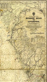
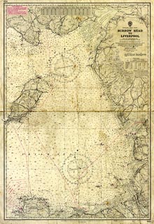
Chart, uncloured engraving with colour details, sheet
1826, Burrow Head to Liverpool, published by the
Hydrographic Office, Admiralty, London, 1953.
Corrected to 1968; printed 1970. |
||

|
Hydrographic Office 1850s onwards | |
| map feature:- | compass rose & up is N & lat and long scales & lat and long grid & sea plain & depth soundings & depth contours & tidal streams & tide tables & sandbanks & buoys & lighthouses & coast line & foreshore sands & harbours & relief & contours & spot heights & rivers & lakes & settlements & roads & railways | |
| inscription:- |
printed upper right
ENGLAND - WEST COAST / BURROW HEAD / TO / LIVERPOOL / FROM THE LATEST INFORMATION / IN THE HYDROGRAHIC DEPARTMENT TO 1953. / The Topography is taken chiefly from the Ordnance Survey. / ... |
|
| wxh, sheet:- | 71x102cm | |
| wxh, map:- | 663x987mm | |
| scale:- | 1 to 200000 ? (nominal at 54d 10m N) | |
|
||