 Andrews 1797

|

|
|
|
item:- National Library of Scotland : EU18.H (9) image:- © National Library of Scotland |
click to enlarge |
|
|
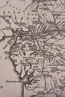
Map, uncoloured engraving, Britannia Romana, scale about
23 miles to 1 inch, by John Andrews, 211 Piccadilly, London,
1797.
Plate 9 between pp.80-81 of the Historical Atlas of England. Based on Ptolemy and the Antonine Itineraries. |
||

|
Andrews 1797 | |
| map feature:- | up is N & lat and long scales (from St Paul's, London, conical projection) & sea plain & coast shaded (?) & rivers & lakes & settlements & roman roads & antiquities | |
| inscription:- |
printed title, upper right
BRITANNIA / ROMANA / collected from / Ptolemy Antonines / Itinerary / by J. Andrews. |
|
| inscription:- |
printed bottom, right and centre
Drawn & Engraved by J. Andrews / Publish'd as the Act directs June 17. 1797. by J. Andrews |
|
| scale line:- | 70 miles = 78.7 mm | |
| scale:- | 1 to 1400000 ? (1 to 1431437 from scale line assuming a statute mile) | |
| scale:- | 1 to 1400000 ? (5d latitude = 387mm) | |
| wxh, map:- | 394x517mm | |