 Andrews 1797

|

|
|
|
item:- National Library of Scotland : EU18.H (8) image:- © National Library of Scotland |
click to enlarge |
|
|
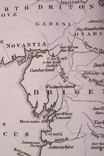
Map, uncoloured engraving, Map of the Ancient Britons of
South Britain, scale about 38 miles to 1 inch, by John
Andrews, 211 Piccadilly, London, 1797.
Plate 8 opposite p.68 of the Historical Atlas of England. |
||

|
Andrews 1797 | |
| map feature:- | up is N & sea plain & coast shaded (?) & rivers & county & tribal areas & settlements | |
| inscription:- |
printed title, upper right
MAP / of the / ANCIENT BRITONS / of / SOUTH BRITAIN / According to Stolome. / by J. Andrews. |
|
| inscription:- |
printed bottom, right and centre
Drawn & Engraved by J. Andrews / Publish'd as the Act directs ... 1797. by J. Andrews |
|
| scale:- | 1 to 2400000 ? (5d latitude = 239mm) | |
| wxh, map:- | 252x317mm | |