 Andrews 1797

|

|
|
|
item:- National Library of Scotland : EU18.H (4) image:- © National Library of Scotland |
click to enlarge |
|
|
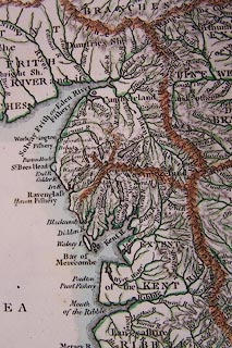
Map, hand coloured engraving, Map of the Rivers or the
Anatomy of England, scale about 29 miles to 1 inch, by John
Andrews, 211 Piccadilly, London, 1797.
Plate 4 opposite p.32 of the Historical Atlas of England. |
||

|
Andrews 1797 | |
| map feature:- | up is N & sea plain & coast shaded (?) & rivers & lakes & relief & hillocks | |
| inscription:- |
printed title, upper right
MAP / of the / RIVERS / or the ANATOMY of / ENGLAND, / with the / Great Ranges of Highlands, / which divide and shew their Extent, / by John Andrews |
|
| inscription:- |
printed bottom, right and centre
Drawn & Engraved by J. Andrews / Publish'd as the Act directs June 17. 1796. by J. Andrews |
|
| scale:- | 1 to 1800000 ? (4d latitude = 244mm) | |
| wxh, map:- | 311X382mm | |