 Andrews 1797

|

|
|
|
item:- National Library of Scotland : EU18.H (3) image:- © National Library of Scotland |
click to enlarge |
|
|
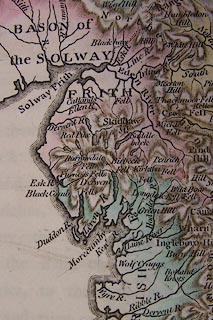
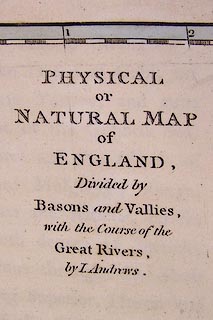
Map, hand coloured engraving, Physical or Natural Map of
England, scale about 36 miles to 1 inch, by John Andrews,
211 Piccadilly, London, 1797.
Plate 3 opposite p.20 of the Historical Atlas of England. |
||

|
Andrews 1797 | |
| map feature:- | up is N & lat and long scales (from St Paul's, London, conical projection) & sea plain & coast form lines & rivers (and river basins) & lakes & relief & hill hachuring | |
| inscription:- |
printed title, upper right
PHYSICAL / OR / NATURAL MAP / OF / ENGLAND, / Divided by / Basons and Vallies, / with the Course of the / Great Rivers, / by J. Andrews. |
|
| inscription:- |
printed bottom, right and centre
Drawn & Engraved by J. Andrews / Publish'd as the Act directs ... 1796. by J. Andrews |
|
| scale:- | 1 to 2300000 ? (5d latitude = 244mm) | |
| wxh, map:- | 254x333mm | |
|
||