 Andrews 1797

|

|
|
|
item:- National Library of Scotland : EU18.H (2) image:- © National Library of Scotland |
click to enlarge |
|
|
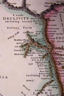
Map, hand coloured engraving, the Summit of the Chain of
Mountains and Great Range of Hills of Albion, scale about 38
miles to 1 inch, by John Andrews, 211 Piccadilly, London,
1797.
Plate 2 opposite p.8 of the Historical Atlas of England. |
||

|
Andrews 1797 | |
| map feature:- | up is N & sea plain & coast line & relief & hillocks | |
| inscription:- |
printed title, upper right
MAP / of the Summit of / The Chain of Mountains / and / Great Range of Hills of / ALBION. / As are supposed to have appeared when the Water / was decreasing after the deluge. / with their Height from / the Level of the Sea, &c. / by John Andrews. |
|
| inscription:- |
printed bottom, right and centre
Drawn & Engraved by J. Andrews / Publish'd as the Act directs June 17. 1796. by J. Andrews |
|
| scale:- | 1 to 2400000 ? (5d latitude = 233mm) | |
| wxh, map:- | 251x324mm | |