 Andrews 1797

|

|
|
|
item:- National Library of Scotland : EU18.H image:- © National Library of Scotland |
click to enlarge |
|
|
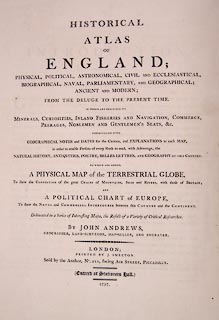
Atlas, Historical Atlas of England, published by John
Andrews, 211 Piccadilly, London, 1797.
The atlas was once in the collection of the Advocates Library, Edinburgh. Separate records are made of some of the maps. |
||

|
Andrews 1797 | |
| inscription:- |
printed title page
HISTORICAL / ATLAS / OF / ENGLAND; / PHYSICAL, POLITICAL, ASTRONOMICAL, CIVIL AND ECCLESIASTICAL, / BIOGRAPHICAL, NAVAL, PARLIAMENTARY, AND GEOGRAPHICAL; / ANCIENT AND MODERN; / FROM THE DELUGE TO THE PRESENT TIME. / IN WHICH ARE DESCRIBED ITS / MINERALS, CURIOSITIES, INLAND FISHERIES AND NAVIGATION, COMMERCE, / PEERAGES, NOBLEMEN AND GENTLEMEN'S SEATS, &c. / INTERSPERSED WITH / GEOGRAPHICAL NOTES and DATES for the Curious, and EXPLANATIONS to each MAP, / in order to enable Persons of every Rank to read, with Advantage, the / NATURAL HISTORY, ANTIQUITIES, POETRY, BELLES LETTRES, and GEOGRAPHY OF THIS COUNTRY. / TO WHICH ARE ADDED, / A PHYSICAL MAP of the TERRESTRIAL GLOBE, / To shew the CONNECTION of the great CHAINS of MOUNTAINS, SEAS, and RIVERS, with those of BRITAIN; / AND / A POLITICAL CHART of EUROPE, / To shew the NAVAL and COMMERCIAL INTERCOURSE between this COUNTRY and the CONTINENT. / Delineated in a Series of Interesting Maps, the Result of a Variety of Critical Researches. / BY JOHN ANDREWS, / GEOGRAPHER, LAND-SURVEYOR, MAP-SELLER, AND ENGRAVER. / LONDON; / PRINTED BY J. SMEETON : / Sold by the Author, No.211, facing AIR STREET, PICCADILLY. / (Entered at Stationers Hall.) / 1797. |
|
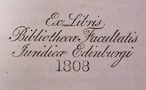
| inscription:- |
stamped (?) fly leaf (?)
Ex Libris / Bibliothecae Facultatis / Juridicae Edinburgi / 1808 |
|
| wxh, page:- | 36.5x43.5cm | |
|
||