 Donald 1783

|

|
|
|
item:- National Library of Scotland : EME.s.118 image:- © National Library of Scotland |
click to enlarge |
|
|
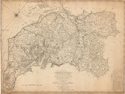
Map, The County of Cumberland, scale about 2 miles to 1
inch, surveyed by Thomas Donald, 1770-71, published by
Joseph Hodskinson, 35 Arundel Street, Strand, London, 1783.
This is a reduced version on one sheet of the 6 sheet 1 inch to 1 mile map published from 1774. Images of the map courtesy of the Trustees of the National Library of Scotland. |
||

|
Donald 1783 | |
| map feature:- | table of symbols & dedication & compass rose & rhumb lines & up is NW & scale line & lat and long scales & sea plain & depth soundings & anchorages & foreshore sands & coast line & rivers & lakes & relief & hill hachuring & woods & trees & forests & parks & county & wards & table of wards & settlements & roads & road distances | |
| inscription:- |
printed lower centre
To The / Most Honourble / Charles Howard, Earl of Surrey. / Lord Lieutenant and Custos Rotulorum / of the West Riding in the County of York, / and of the City of York, & County of the same, / Deputy Earl Marshall of England, / and One of the Lords Commissioners / of His Majesty's Treasury / This MAP of the / COUNTY of CUMBERLAND, / (Surveyed in 1770 & 1771, by Thomas Donald.) / is most humbly Inscribed by / His Lordships most Obedient / and obliged humble Servants / Joseph Hodskinson & Thomas Donald. |
|
| inscription:- |
printed bottom
London. Publish'd Sepr. 1st. 1783, by J. Hodskinson & T. Donald No.35 Arundel Street, Strand. |
|
| inscription:- |
printed with scale line
Scale of Statute Miles |
|
| scale line:- | 10+1 miles = 135.6 mm (?) | |
| wxh, sheet:- | 64x84cm | |
| wxh, map:- | 610x818mm | |
| scale:- | 1 to 130000 ? (1 to 130551 from scale line) | |