 Houghton 1948

|

|
|
|
item:- Kendal Library (26) image:- © see bottom of page |

click to enlarge |
|
|
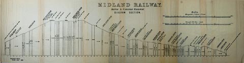
Railway map, uncoloured lithograph, Map of the Settle
Carlisle Line, scale about 8 miles to 1 inch, by Frederick W
Houghton, published by Norman Arch Publications, Bradford,
Yorkshire, 1948.
Tipped in at the back of The Story of the Settle Carlisle Line, by Frederick W Houghton and W Hubert Foster. |
||

|
Houghton 1948 | |
| map feature:- | compass rose & up is N & settlements & railways | |
| inscription:- |
printed upper right
MAP OF THE / SETTLE-CARLISLE LINE / Scale approx., One inch = Eight miles. |
|
| w:- | 18cm (approx) | |
| scale:- | 1 to 500000 ? (nominal, approximate) | |
|
||