 Bazaar 1890

|

|
|
|
item:- JandMN (458) image:- © see bottom of page |
click to enlarge |
|
|
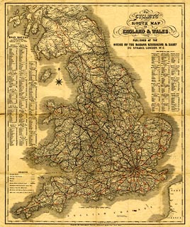
Road map, The Cyclist's Route Map of England and Wales,
scale about 15 miles to 1 inch, published by the Bazaar
Exchange and Mart Office, 170 Strand, London, about 1890-96.
|
||

|
Bazaar 1890 | |
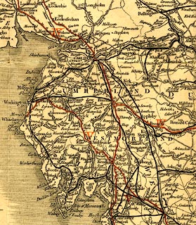
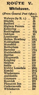
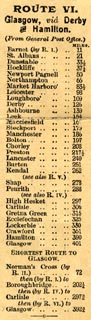
| map feature:- | folded (6x4) & card cover & advertisements (reverse of map and cover, one advert mentions 1896) & compass rose & up is N & scale line & lat and long scales (trapezoidal projection; longitude from Greenwich) & sea shaded & coast shaded & rivers & lakes & county & settlements & roads & turnpike roads & road distances & distances from London & electoral data & railways & canals | |
| inscription:- |
printed title
The / CYCLIST'S / ROUTE MAP OF / ENGLAND & WALES. / PUBLISHED AT THE OFFICE OF THE BAZAAR EXCHANGE & MART / 170, STRAND, LONDON. W.C. |
|
| inscription:- |
printed bottom
PRINTED ON PARCHMENT PAPER SPECIALLY MADE FOR THIS MAP. |
|
| inscription:- |
printed cover
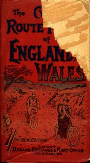
The C[Y ] / ROUTE [ ] / of ENGLAN[D ] / WALES / 1/- NEW EDITION // LONDON / BAZAAR EXCHANGE & MART OFFICE / 170 STRAND WC black and grey on red; illustration of 2 cyclists on safety bicycles of about 1895 |
|
| inscription:- |
printed with scale line
British Statute Miles |
|
| scale line:- | 60 miles = 101.5 mm | |
| wxh, cover:- | 12x20.5cm | |
| wxh, sheet:- | 66.5x79cm | |
| wxh, map:- | 622x766mm | |
| scale:- | 1 to 950000 ? (1 to 951336 from scale line) | |
|
||

|
||
|
||
|
||
|
||
|
||
|
|
notes | |