 Bazaar 1890

|

|
|

|
back to object record | |
| Map Features | ||
|
|
||
|
title
map maker |
Printed title:-

The CYCLIST'S ROUTE MAP OF ENGLAND & WALES. PUBLISHED AT THE OFFICE OF THE BAZAAR EXCHANGE & MART 170, STRAND, LONDON. W.C. Printed at the bottom:- PRINTED ON PARCHMENT PAPER SPECIALLY MADE FOR THIS MAP. Printed on the cover, black and grey on red, with an illustration of 2 cyclists on safety bicycles of about 1895:- The C[Y ] ROUTE [ ] of ENGLAN[D ] WALES 1/- NEW EDITION / LONDON BAZAAR EXCHANGE & MART OFFICE 170 STRAND WC |
|
|
|
||
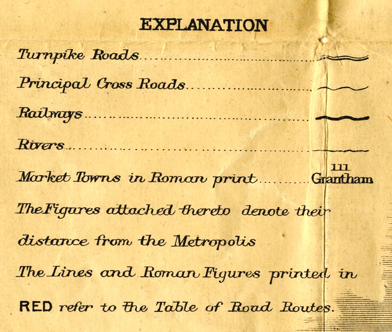
| table of symbols |
A table of symbols is printed lower left:-
|
|
|
|
||
|
orientation
compass rose up is N |
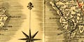
Printed in the Irish Sea is a compass rose; no circle, star points for cardinal and half cardinal directions, North marked by a fleur de lys. The map is printed with North at the top. |
|
|
|
||
|
scale line
scale |
There is a scale line of:-
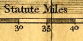
British Statute Miles The 60 miles = 101.5 mm gives a scale 1 to 951336. The maps scale is about 1 to 950000 15 miles to 1 inch. |
|
|
|
||
|
sea area
sea plain |
The sea area is plain. Some sea areas are labelled,
eg:-
SOLWAY FIRTH Allonby Bay Bay of Morecambe |
|
|
|
||
|
coast line
coast shaded headlands |
The coast line is emphasized by two levels of shading, extending into the offing. A headland might be labelled, eg:- St. Bees Heads. |
|
|
|
||
| rivers |
Rivers are drawn by a wiggly line tapering upstream. Some rivers are labelled, eg:- R. Eden Eamont R. Rivers cross roads sometimes interrupting the stream, sometimes not; nothing can be implied about bridges. |
|
|
|
||
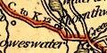
| lakes |
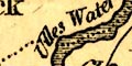
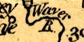
Lakes are drawn in outline, the shore shaded. Some lakes are labelled:- Bassenthwaite Water Broader Water [Brothers Water] Coniston Water Crammock Water Ennerdale Water Hals Water [Hawes Water] Loweswater Thirk Mere [Thirlmere] Ulles Water Wast Water Other lakes might be recognized, eg:- Buttermere lake Codale Tarn (?) Derwent Water Devoke Tarn Easedale Tarn (?) Esthwaite Water Hayes Water (?) |
|
|
|
||
| county |
County boundaries are a dotted line, which is mostly continued alongside a boundary feature such as a river. The county areas are labelled, eg:- WESTMORELAND CUMBERLAND Windermere is shown entirely in Lancashire; Ullswater is correctly shown part in Westmorland, part in Cumberland. |
|
|
|
||
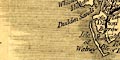
| settlements |
Settlements are marked by nothing, a block or two, or a
circle, perhaps with added elements, and differentiated by
style of labelling.
|
|
|
cities
distances from London |
nothing, labelled in upright block caps:-
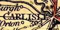
CARLISLE [2 stars] / 307 |
|
|
The number is the distance from London.
|
||
|
towns
distances from London |
nothing or perhaps a block; labelled in upright lowercase
text, eg:-
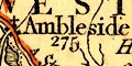
Ambleside / 275 Penrith / 285 Kendal [2 stars] |
|
|
villages
hamlets |
a circle;labelled in italic lowercase text, eg:-
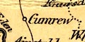
Cumrew |
|
|
The number with the name is the distance from London.
The stars are for members sent to Parliament: 2 for Carlisle, 2 for Cockermouth, 1 for Whitehaven, 1 for Kendal. |
||
|
|
||
|
roads
road distances |
Roads are drawn by a double or single line, for more or less important roads. Distances from place to place are given alongside some routes, eg:- H. N. to P. 12 Ken. to Pen. 25 K. to S. 11 The places are obvious when using the map! Some major routes are tinted red, and labelled in roman numerals. Routes IV, V and VI are relevant to Westmorland and Cumberland. route IV - from Boro'bridge through Richmond, Yorkshire; then Brough, Appleby, Penrith to Carlisle, Cumberland; into Scotland at Gretna Green, on to Glasgow. route V - from the south, through Settle, Yorkshire; then Kirkby Lonsdale, Kendal, Windermere, Ambleside, Grasmere, Westmorland; Keswick, Pheasant Inn, Cockermouth, to Whitehaven, Cumberland. route IV - from the south, through Lancaster, Lancashire; then Burton, Kendal, Shap, Westmorland; Penrith, High Hesket, to Carlisle, Cumberland; into Scotland at Gretna Green, an on to Glasgow. |
|
|
|
||
| sands roads |
The road across Lancaster Sands is not drawn, but it is
labelled:-
Fordable at Low Water |
|
|
|
||
| miscellany | ||
|
|
||
|
antiquities
roam wall |
Hadrians Wall is a bold line with fence palings:-
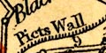
Picts Wall |
|
Lakes Guides menu.