 Dispatch 1863

|

|
|
|
item:- JandMN (443) image:- © see bottom of page |
click to enlarge |
|
|
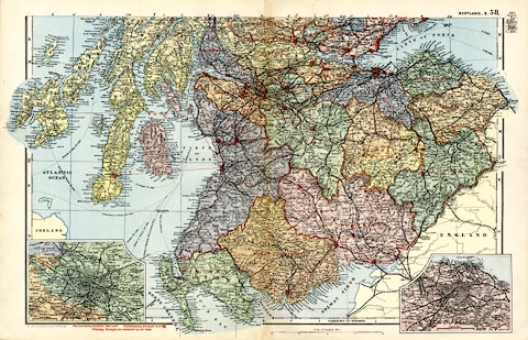
Map, colour lithograph, Scotland S, scale about 9 miles
to 1 inch, first drawn by Edward Weller for the Weekly
Dispatch newspaper, 1856-62, published by G W Bacon, Bacon's
Geographical Establishment, London, 1895-97.
Plate 58 in the Commercial and Library Atlas of the British Isles. There are inset maps of Edinburgh and Glasgow; railways are a prominent feature. Version of this map were published from 1850s to 1930s. |
||

|
Dispatch 1863 | |
| map feature:- | up is N & scale line & lat and long scales & index grid (d..l,K..Q for this sheet) & sea tinted & coast tinted & rivers & lakes & relief & hill hachuring & county & electoral data & settlements & roads & canals & railways | |
| inscription:- |
printed bottom left
Bacon's Geographical Establishment |
|
| inscription:- |
printed with scale line
Scale of English Miles |
|
| scale line:- | 40 miles = 112.0 mm | |
| wxh, sheet:- | 53.5x34.5cm | |
| wxh, map:- | 482x308mm | |