 Skrine 1801

|

|
|
|
item:- JandMN (421) image:- © see bottom of page |
click to enlarge |
|
|
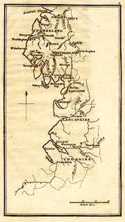
Map, uncoloured engraving, rivers in Cumberland,
Westmorland, Lancashire and Cheshire, scale about 23 miles
to 1 inch, by Henry Skrine, published by P Elmsly, London,
1801.
Included in A General Account of all the Rivers of Note in Great Britain. |
||

|
Skrine 1801 | |
| map feature:- | north point & up is N & scale line & sea plain & coast shaded & rivers & lakes & county & settlements | |
| inscription:- |
printed with scale line
British Miles |
|
| scale line:- | 30 miles = 33.4 mm | |
| wxh, sheet:- | 14x2.5cm | |
| wxh, map:- | 102x182mm | |
| scale:- | 1 to 1400000 ? (1 to 1445519 from scale line) | |