 Greenwood 1834

|

|
|
|
item:- JandMN (412) image:- © see bottom of page |
click to enlarge |
|
|
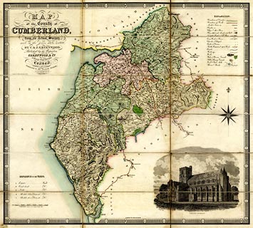
Map, hand coloured engraving, Map of the County of
Cumberland, scale about 3 miles to 1 inch, by C and J
Greenwood, published by Greenwood and Co, 13 Regent Street,
Pall Mall, London, 1830-34.
Reduced from their 1 inch map of 1824. |
||

|
Greenwood 1834 | |
| map feature:- | sectioned for folding & mounted (on linen?) & folded (3x6) & piano key border & vignettes (Carlisle Cathedral) & table of symbols & compass rose & up is N & scale line & lat and long scales & sea plain & coast form lines & rivers & lakes & relief & hill hachuring & hill shading & woods & forests & county & wards & table of wards & settlements & roads & road distances & turnpike roads & canals | |
| inscription:- |
printed title, upper left
MAP / of the County of / CUMBERLAND, / from an Actual Survey, / made in the Years 1821, & 1822, / BY C. & J. GREENWOOD. / Published by the Proprietors / GREENWOOD & Co. / 13, Regent Street, Pall Mall, / LONDON. / Corrected to the Present Period, / AND PUBLISHED FEBY. 24th. 1830. / ENGRAVED BY J. DOWER, PENTONVILLE, LONDON. |
|
| inscription:- |
printed with scaleline
SCALE OF MILES |
|
| scale line:- | 10 + 1 miles = 91.6 mm | |
| wxh, folded:- | 24.5x11cm | |
| wxh, sheet:- | 74.5x64.5cm | |
| wxh, map (inccluding gaps):- | 694x623mm | |
| scale:- | 1 to 190000 ? (1 to 193262 from scale line) | |