 Creighton 1889 map

|

|
|
|
item:- JandMN (376_2) image:- © see bottom of page |
click to enlarge |
|
|
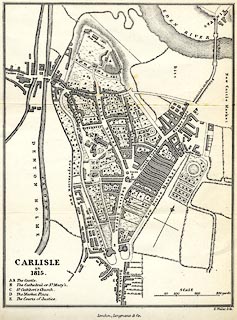
Map, uncoloured lithograph reproduction, Carlisle in
1815, scale about 10 inches to 1 mile, litho by E Weller,
published by Longmans and Co, London, 1889.
Folded and tipped in opposite p.189 in Carlisle, by M Creighton, in the Historic Towns series, edited by Edward A Freeman and William Hunt, published by Longmans, Green, and Co, London, 2nd edn 1889. |
||

|
Creighton 1889 map | |
| map feature:- | scale line & up is NW (roughly) & rivers & bridges & settlements & streets & roads | |
| inscription:- |
printed lower right
CARLISLE / in / 1815. |
|
| inscription:- |
printed bottom right, centre
E. Weller litho. / London; Longmans & Co. |
|
| inscription:- |
printed with scale line
SCALE / yards |
|
| scale line:- | 300 yards = 43.0 mm | |
| wxh, sheet:- | 18x26cm | |
| wxh, map:- | 153x201mm | |
| scale:- | 1 to 6400 ? (1 to 6380 from scale line) | |