 Railway Clearing House 1879

|

|
|
|
item:- Brunel University Library : 8120 image:- © Brunel University Library |
click to enlarge |
|
|
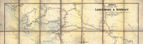
Railway map, photocopy, Airey's Railway Map of Lancashire
and District, scale about 2 miles to 1 inch, by John Airey,
engraved by J P and W R Emslie, published by John Airey,
Railway Clearing House, London, 1879.
Railways are tinted to indicate the railway company, listed in a table; stations and junctions are clearly marked, with distances between them; running powers and other working arrangments are tabulated. |
||

|
Railway Clearing House 1879 | |
| map feature:- | compass rose & up is N & table of symbols & sea plain & coast tinted & rivers & lakes & relief & hill hachuring & county & settlements & railways | |
| inscription:- |
printed title, upper centre
AIREY'S / RAILWAY MAP OF / LANCASHIRE & DISTRICT / Scale - Two Miles to an Inch / BY JOHN AIREY / AND / CERTIFIED BY THE COMPANIES / 1879 |
|
| inscription:- |
printed lower left, centre, right
J.P.& W.R. EMSLIE, ENGRAVERS & LITHRS., LONDON / PUBLISHED BY J. AIREY, RAILWAY CLEARING HOUSE, LONDON. Other Maps of this Series - ... / ENTERED AT STATIONERS HALL. |
|
| wxh, map:- | 74x104cm (approx) | |
| scale:- | 1 to 126720 ? (nominal) | |