 Symons 1860 maps

|

|
|
|
item:- Armitt Library : A4038.1 image:- © see bottom of page |
click to enlarge |
|
|
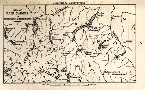
Map, uncoloured lithograph, Site of Rain Gauges in
Cumberland and Westmorland, scale about 4 miles to 1 inch,
by G J Symons, published by Edward Stanford and Co, 6
Charing Cross, and Simpkin, Marshall and Co, Stationers'
Hall Court, London, 1870.
Tipped in opposite p.130 of British Rainfall 1869. |
||

|
Symons 1860 maps | |
| map feature:- | up is N & scale line & rivers & lakes & rain gauges | |
| inscription:- |
printed upper left
Site of / RAIN GAUGES / in / CUMBERLAND & WESTMORLAND |
|
| inscription:- |
printed with scale line
SCALE OF STA. MILES |
|
| scale line:- | 8 miles = 49.7 mm | |
| wxh, sheet:- | 21x13.5cm | |
| wxh, map:- | 171x100mm | |
| scale:- | 1 to 260000 ? (1 to 259049 from scale line) | |