 Linton 1852 map

|

|
|
|
item:- Armitt Library : A1082.20 image:- © see bottom of page |
click to enlarge |
|
|
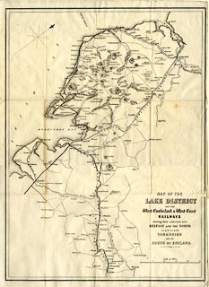
Map, uncoloured lithograph? Map of the Lake District and
the West Cumberland and West Coast Railways, scale about 6
miles to 1 inch, engraved by W Banks and Son, Edinburgh,
perhaps published by Alexander Ireland and Co, 22 Market
Street, Manchester, 1860-61.
Bound with two guide books, Over Sands to the Lakes, and The Seaside Lakes and Mountains, by Edwin Waugh. This map was used earlier, engraved by W H Lizars, Edinburgh, Scotland, 1852, in A Handbook of the Whitehaven and Furness Railway, by John Linton; perhaps this is a lithograph copy by Banks? |
||

|
Linton 1852 map | |
| map feature:- | folded (4x4) & north point & up is NW & scale line & sea plain & coast form lines & rivers & lakes & relief & hill hachuring & parks & settlements & roads & railways | |
| inscription:- |
printed lower right
MAP OF THE / LAKE DISTRICT / AND THE / West Cumberland & West Coast / RAILWAYS / shewing their connection with / BELFAST AND THE NORTH / as well as with / YORKSHIRE / and the SOUTH OF ENGLAND. / ENGRAVED BY W. BANKS & SON, EDINR. |
|
| inscription:- |
printed with scale line
Scale of Miles |
|
| scale line:- | 25 miles = 104.7 mm | |
| wxh, sheet:- | 36x50cm | |
| wxh, map:- | 347x484mm | |
| scale:- | 1 to 380000 ? (1 to 384275 from scale line) | |