 Murray 1889 map

|

|
|
|
item:- Armitt Library : A1166.1 image:- © see bottom of page |
click to enlarge |
|
|
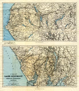
Map, colour printed lithograph, 2 sheets, A New Map of
the Lake District of Cumberland, Westmoreland and
Lancashire, scale about 2 miles to 1 inch, by Stanford's
Geographical Establishment from Ordnance Survey data,
published by John Murray, Albemarle Street, London, edn
1889.
Folded and inserted in pockets in front and back covers of A Handbook to the English Lakes. Four sections of the map are repeated, with hill shading, tipped into the text of the guide book. |
||

|
Murray 1889 map | |
| map feature:- | folded (6x3) & up is N & scale line & lat and long scales (Longitude West of Greenwich) & lat and long grid (10x10 minutes) & sea tinted & coast line & foreshore sands & rivers & lakes & relief & spot heights & woods & forests & parks & county & settlements & roads & canals & railways | |
| inscription:- |
printed lower left, S sheet
A NEW MAP / OF THE / LAKE DISTRICT / OF / CUMBERLAND, WESTMORLAND / AND / LANCASHIRE / CHIEFLY FROM THE ORDNANCE SURVEY |
|
| inscription:- |
printed bottom right, centre, each sheet
Stanford's Geographical Establishment / London : John Murray, Albemarle Street. |
|
| inscription:- |
printed with scale line
SCALES / 2 Eng. Stat. Miles to one Inch or 1/126.720th. of Nature / English Statute Miles |
|
| scale line:- | 5+1 miles = 76.5 mm | |
| wxh, N sheet:- | 55.5x35cm | |
| wxh, S sheet:- | 55.5x36.5cm | |
| wxh, N map:- | 512x270mm | |
| wxh, S map:- | 516x282mm | |
| scale:- | 1 to 130000 ? (1 to 126223 from scale line) | |
|
|
notes | |