 Wyld 1847

|

|
|
|
item:- Armitt Library : A1201.64 image:- © see bottom of page |
click to enlarge |
|
|
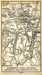
Map, uncoloured engraving, Windermere, Rydal, Grasmere,
Esthwaite and Coniston Waters, scale about 3.5 miles to 1
inch, by James Wyld, published by John Johnstone,
Paternoster Row, London, et al, 1847.
Tipped in opposite p.49 of Sylvan's Pictorial Guide to the English Lakes. |
||

|
Wyld 1847 | |
| map feature:- | plain cartouche & north point & up is N & scale line & rivers & lakes & relief & hill hachuring & county & settlements & roads & railways | |
| inscription:- |
printed bottom
WINDERMERE, RYDAL, GRASMERE, / ESTHWAITE AND CONISTON WATERS. |
|
| inscription:- |
printed with scale line
Scale of Miles. |
|
| scale line:- | 10 miles = 71.9 mm | |
| wxh, sheet:- | 10.5x16.5cm | |
| wxh, map:- | 83x148mm | |
| scale:- | 1 to 220000 ? (1 to 223831 from scale line) | |