 Cooke 1802

|

|
|
|
item:- Armitt Library : A1367.1 image:- © see bottom of page |
click to enlarge |
|
|
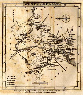
Road map, uncoloured engraving, Westmoreland, scale about
11.5 miles to 1 inch, published by George Alexander Cooke,
17 Paternoster Row, London, 1803-10.
Frontispiece to a Topographical and Statistical Description of the County of Westmoreland. |
||

|
Cooke 1802 | |
| map feature:- | folded (2x1) & plain cartouche (shaded) & compass rose & up is E & scale line & lat and long scales (rectangular projection) & coast form lines & rivers & lakes & forests & parks & county & wards & table of wards & settlements & roads & distances from London & canals (?) | |
| inscription:- |
printed upper centre
WESTMORELAND |
|
| inscription:- |
printed bottom
The County Town is denoted by red and the respective Hundreds of the County by different Colours, / which distinctions are peculiar to the superior Edition. |
|
| inscription:- |
printed with scale line
Scale of Statute Miles |
|
| scale line:- | 10 miles = 22.1 mm | |
| wxh, sheet:- | 13x14.5cm | |
| wxh, map:- | 109x122mm | |
| scale:- | 1 to 730000 ? (1 to 728210 from scale line) | |