 Jopling 1843 map

|

|
|
|
item:- Armitt Library : A1636.14 image:- © see bottom of page |
click to enlarge |
|
|
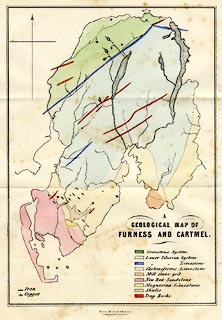
Map, hand coloured lithograph, A Geological Map of
Furness and Cartmel, Lancashire, litho by Maclure, Macdonald
and Macgregor, Liverpool, published by Whittaker and Co, Ave
Maria Lane, London and by Stephen Soulby, Ulverston,
Cumberland, 1843.
Folded and tipped in opposite p.63 of a Sketch of Furness and Cartmel, by Charles M Jopling. |
||

|
Jopling 1843 map | |
| map feature:- | north point & up is N & sea plain & coast line & rivers & lakes & geology & table of strata | |
| inscription:- |
printed lower right
A / GEOLOGICAL MAP OF / FURNESS & CARTMEL. |
|
| inscription:- |
printed bottom
Maclure, Macdonald & Macgregor. / Lithographers, Liverpool. |
|
| wxh, sheet:- | 16x20.5cm | |
| wxh, map:- | 122x182mm | |