 Wyld 1847

|

|
|
|
item:- Armitt Library : A1201.67 image:- © see bottom of page |
click to enlarge |
|
|
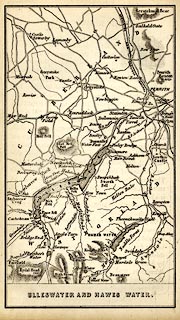
Map, uncoloured engraving, Ulleswater and Hawes Water,
Cumberland and Westmorland, scale about 3.5 miles to 1 inch,
by James Wyld, published by John Johnstone, Paternoster Row,
London, et al, 1847.
Tipped in opposite p.229 of Sylvan's Pictorial Guide to the English Lakes. |
||

|
Wyld 1847 | |
| map feature:- | plain cartouche & up is N & rivers & lakes & relief & hill hachuring & spot heights & county & settlements & roads & railways | |
| inscription:- |
printed bottom
ULLESWATER AND HAWES WATER. |
|
| wxh, sheet:- | 10.5x16.5cm | |
| wxh, map:- | 84x148mm | |
| scale:- | 1 to 220000 ? (guess) | |