 Pearson 1900s map

|

|
|
|
item:- Armitt Library : A1188.2 image:- © see bottom of page |
click to enlarge |
|
|
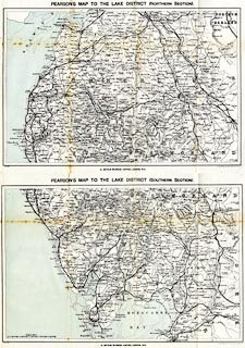
Map, colour lithograph, Pearson's Map to the Lake
District, two sheets, Northern Section and Southern Section,
Westmorland, Cumberland etc, scale about 4 miles to 1 inch,
by George Philip and Son, London, published by C Arthur
Pearson, Henrietta Street, London, 1900s.
Folded and tipped in before the text of Pearson's Gossipy Guide to the English Lakes and Neighbouring Districts. |
||

|
Pearson 1900s map | |
| map featuire:- | folded (4x2) & up is N & scale line & sea tinted & sandbanks & coast line & foreshore & rivers & lakes & relief & hill hachuring & spot heights & forests & parks & county & settlements & roads & railways & canals & sands roads | |
| inscription:- |
printed top, N section
PEARSON'S MAP TO THE LAKE DISTRICT (NORTHERN SECTION). |
|
| inscription:- |
printed top, S section
PEARSON'S MAP TO THE LAKE DISTRICT (SOUTHERN SECTION). |
|
| inscription:- |
printed bottom left, right, centre
Copyright / George Philip & Son, London & Liverpool / C. ARTHUR PEARSON, LIMITED, LONDON, W.C. |
|
| inscription:- |
printed with scale line
English Miles. |
|
| scale line:- | 10 miles = 62.0 mm | |
| wxh, N sheet:- | 33x23.5cm | |
| wxh, S sheet:- | 33x24.5cm | |
| wxh, N map:- | 308x206mm | |
| wxh, S map:- | 312x205mm | |
| scale:- | 1 to 260000 ? (1 to 259572 from scale line) | |