 Cooke 1802

|

|
|
|
item:- Armitt Library : A1121.5 image:- © see bottom of page |
click to enlarge |
|
|
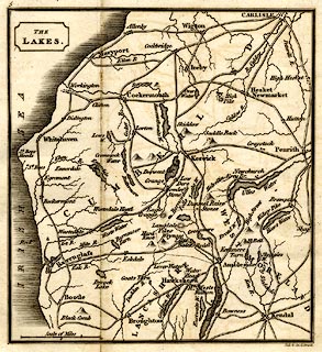
Map, uncoloured engraving, The Lakes, scale about 8.5
miles to 1 inch, engraved by Neels and Son, Strand,
published by Sherwood, Jones and Co, Paternoster Row,
London, about 1827?
Opposie p.1 in The Tourist's and Traveller's Companion to the Lakes, by Charles Cooke. |
||

|
Cooke 1802 | |
| map feature:- | folded (1x3) & plain cartouche & up is N & scale line & sea plain & coast shaded & rivers & lakes & relief & hill hachuring & county & settlements & roads | |
| inscription:- |
printed upper left
THE / LAKES. |
|
| inscription:- |
printed bottom right
Neele & Son sc. Strand. |
|
| inscription:- |
printed with scale line
Scale of Miles |
|
| scale line:- | 10 miles = 30.5 mm | |
| wxh, sheet:- | 15x15cm | |
| wxh, map:- | 117x127mm | |
| scale:- | 1 to 530000 ? (1 to 527654 from scale line) | |