 Geological Survey, One Inch

|

|
|
|
item:- JandMN (104_19) image:- © see bottom of page |
click to enlarge |
|
|
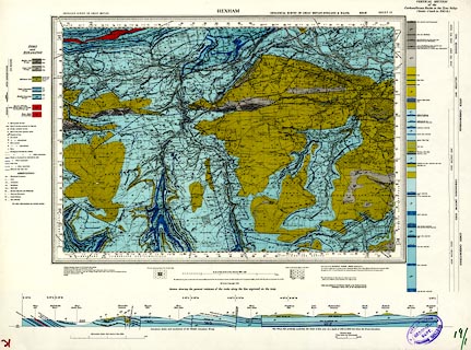
Geological map, sheet 19, Hexham area, Northumberland and
Cumberland, scale 1 inch to 1 mile, published for the
Geological Survey of Great Britain, by the Ordnance Survey,
Southampton, Hampshire, 1956.
solid edition, colour printed. |
||

|
Geological Survey, One Inch | |
| map feature:- | geology & stratigraphical column & geological section | |
| scale:- | 1 to 63360 ? (nominal) | |
| wxh, sheet:- | 66.5x48.5cm | |
| wxh, map:- | 493x342mm | |