 Nelson 1859 map

|

|
|
|
item:- JandMN (336_2) image:- © see bottom of page |
click to enlarge |
|
|
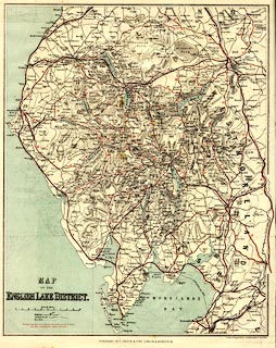
Map, colour lithograph, Map of the English Lake District,
scale about 3.5 miles to 1 inch, drawn and engraved by John
Bartholomew and Son, Edinburgh, published by T Nelson and
Sons, Paternoster Row, London, and Edinburgh and New York,
United States, 1859.
The routes, road or rail, corresponding to itineraries in the guide book are tinted red and numbered to link to the book. Folded and tipped in opposite p.9 of a guide book, The English Lakes in Nelson's Handbooks for Tourists series. |
||

|
Nelson 1859 map | |
| map feature:- | folded (4x3) & table of symbols & up is N & scale line & sea tinted & coast line & rivers & lakes & relief & hill hachuring & forests & parks & county & settlements & roads & canals & railways | |
| inscription:- |
printed lower left
MAP / OF THE / ENGLISH LAKE DISTRICT. |
|
| inscription:- |
printed bottom right, centre
Drawn & Engraved by J. Bartholomew & Son, Edin. / PUBLISHED BY T. NELSON & SONS, LONDON & EDINBURGH. |
|
| inscription:- |
printed with scale line
British Miles |
|
| scale line:- | 10 miles = 68.8 mm | |
| wxh, sheet:- | 31.5x40cm | |
| wxh, folded:- | 9.5x17cm | |
| wxh, map:- | 287x357mm | |
| scale:- | 1 to 230000 ? (1 to 233916 from scale line) | |