 Cary 1787

|

|
|
|
item:- private collection (177) image:- © see bottom of page |
click to enlarge |
|
|
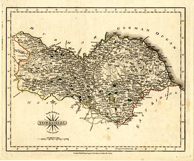
Map, hand coloured engraving, North Riding of Yorkshire,
scale about 9 miles to 1 inch, by John Cary, Strand, London,
1787, edn 1793.
Plate 42 in Cary's New and Correct English Atlas. |
||

|
Cary 1787 | |
| map feature:- | compass rose cartouche & compass rose & scale line & lat and long scales (W from London, rectangular projection) & sea plain & coast form lines & rivers & relief & hill hachuring & woods & forests & parks & county & settlements & roads | |
| inscription:- |
printed lower left, above, in and below title cartouche
North Riding of / YORKSHIRE / By JOHN CARY Engraver. |
|
| inscription:- |
printed bottom
London : Publish'd Jan 1st. 1793, by J. Cary, Engraver & Mapseller Strand. |
|
| inscription:- |
printed above scale line
Statute Miles 69 1/2 to a Degree. |
|
| scale line:- | 16 miles = 45.5 mm | |
| wxh, sheet:- | 28.5x24cm | |
| wxh, plate:- | 276x227mm | |
| wxh, map:- | 262x212mm | |
| scale:- | 1 to 570000 ? (1 to 565923 from scale line) | |