 Jollie 1794

|

|
|
|
item:- private collection (170) image:- © see bottom of page |
click to enlarge |
|
|
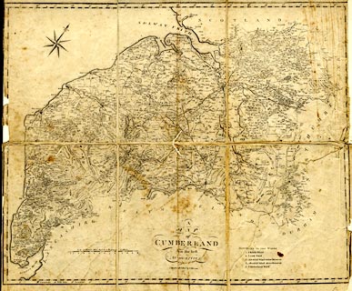
Map, uncoloured engraving, A Map of Cumberland, scale
about 3.5 miles to 1 inch, engraved by James Kennedy,
published by F Jollie, Carlisle, Cumberland, 1794.
Included in the History of the County of Cumberland, by William Hutchinson. |
||

|
Jollie 1794 | |
| map feature:- | sectioned for folding (3x2) & mounted (on paper) & compass rose & up is NW & scale line & lat and long scales & sea plain & coast form lines & & rivers & lakes & relief & hill hachuring & woods & forests & parks & county & wards & table of wards & settlements & roads | |
| inscription:- |
printed lower centre
A / MAP / of / CUMBERLAND / from the best / AUTHORITIES. / Ja. Kennedy Sculpt. / CARLISLE Published by F. JOLLIE |
|
| inscription:- |
printed with scale line
Scale of Statute Miles 69 1/2 to a Degree of Latitude. |
|
| scale line:- | 12+1 miles= 97.0 mm | |
| wxh, map:- | 498x402mm | |
| scale:- | 1 to 220000 ? (1 to 215685 from scale line) | |