 Blome 1673

|

|
|
|
item:- private collection (168) image:- © see bottom of page |
click to enlarge |
|
|
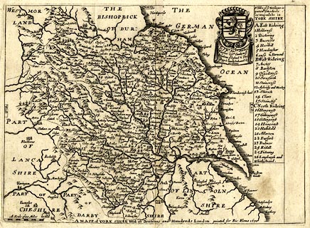
Map, uncoloured engraving, Mapp of York Shire, scale
about 7 miles to 1 inch, by Richard Blome, 1670, probably
engraved by Richard Palmer, published, London, 1673.
The map has a dedication to and the coat of arms of Charles Lord Fairfax. Included in Britannia: or, A Geographical Description of the Kingdoms of England, Scotland, and Ireland, ... |
||

|
Blome 1673 | |
| map feature:- | labelled borders (English) & up is N & scale line & sea plain & coast shaded & rivers & relief & hillocks & woods & parks & county & hundreds & table of hundreds & settlements | |
| inscription:- |
printed lower centre
A MAPP of YORK SHIRE With its Divisions and Hundreds London printed for Ric : Blome 1670 |
|
| inscription:- |
printed upper right
To ye Honble. Charles Ld. / Fairfax Visct. Emula in ye / Kingdome of Ireland &. This / Mapp is humbly Dedicated by / Ric : Blome coat of arms and drape cartouche |
|
| inscription:- |
printed with scale line
A Scale of 10 Miles |
|
| scale line:- | 10 miles = 36.6 mm | |
| scale:- | 1 to 440000 ? (1 to 439711 from scale line wrongly assuming a statute mile) | |
| wxh, sheet:- | 28.5x22.5cm | |
| wxh, map:- | 280x205mm | |