 Morden 1695

|

|
|
|
item:- private collection (165) image:- © see bottom of page |
click to enlarge |
|
|
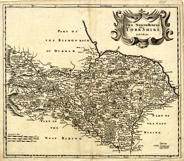
Map, uncoloured engraving, The North Riding of Yorkshire,
scale about 4 miles to 1 inch, by Robert Morden, published
by Abel Swale, Awnsham, and John Churchill, London, 1695.
Included in Camden's Britannia, Newly Translated into English, by Edmund Gibson, Queens College, Oxford, published by Abel Swale, the Unicorn, St Paul's Churchyard, Awnsham, and John Churchill, the Black Swan, Paternoster Row, London, 1695. |
||

|
Morden 1695 | |
| map feature:- | scroll cartouche & up is N & scale lines & lat and long scales & rivers & relief & hillocks & woods & parks & county & settlements & roads | |
| inscription:- |
printed title cartouche, upper right
THE NORTH RIDING / OF / YORKSHIRE / by Robt. Morden. |
|
| inscription:- |
printed lower right
Sold by / Abel Swale / Awnsham and / John Churchill |
|
| inscription:- |
printed with 3 scale lines
A Scale of 10 Miles / Great / Middle / Small |
|
| scale line:- | 10 miles = 64.3 mm | |
| scale line:- | 10 miles = 62.6 mm | |
| scale line:- | 10 miles = 56.2 mm | |
| scale:- | 1 to 260000 ? (1 to 263683 average from scale lines, wrongly assuming a statute mile) | |
| wxh, sheet:- | 44x39cm | |
| wxh, map:- | 417x360mm | |