 Morden 1695

|

|
|
|
item:- private collection (163) image:- © see bottom of page |
click to enlarge |
|
|
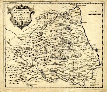
Map, uncoloured engraving, Episcopatus Dunelmensis, The
Bishoprick of Durham, scale about 2.5 miles to 1 inch, by
Robert Morden, published by Abel Swale, Awnsham, and John
Churchill, London, 1695.
Included in Camden's Britannia, Newly Translated into English, by Edmund Gibson, Queens College, Oxford, published by Abel Swale, the Unicorn, St Paul's Churchyard, Awnsham, and John Churchill, the Black Swan, Paternoster Row, London, 1695. |
||

|
Morden 1695 | |
| map feature:- | scroll cartouche & up is N & scale lines & lat and long scales (W from London? slanted rectangular projection) & sea plain & coast shaded & rivers & relief & hillocks & woods & parks & county & settlements & roads | |
| inscription:- |
printed title cartouche, upper left
EPISCOPATUS / DUNELMENSIS / Vulgo / The Bishoprick of / DURHAM / by Robt. Morden. |
|
| inscription:- |
printed lower right
Sold by Abel Swale / Awnsham & John / Churchil. |
|
| inscription:- |
printed above and with 2 scale lines
A Scale of 5 Miles |
|
| scale line:- | 5 miles = 54.8 mm | |
| scale line:- | 5 miles = 50.1 mm | |
| scale:- | 1 to 150000 ? (1 to 153417 average from scale lines, wrongly assuming a statute mile) | |
| wxh, sheet:- | 45.5x39cm | |
| wxh, map:- | 420x363mm | |