 Baines 1822

|

|
|
|
item:- private collection (156) image:- © see bottom of page |
click to enlarge |
|
|
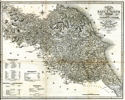
Map, uncoloured engraving, Map of the East and North
Ridings of the County of York, scale about 5.5 miles to 1
inch, by Charles Fowler, published by Edward Baines, Leeds,
Yorkshire, 1822.
Included in a History, Directory and Gazetter of the County of York. |
||

|
Baines 1822 | |
| map feature:- | folded (3x2) & table of symbols & up is N & scale line & lat and long scales & rivers & lakes & relief & hill hachuring & table of heights & parks & county & hundreds (wapontakes) & table of hundreds & settlements & roads & turnpike roads & post roads & road distances & distances from London & markets & canals | |
| inscription:- |
printed title, upper right
Map / OF THE / EAST & NORTH / Ridings / OF THE / COUNTY of YORK, / Including the latest Improvements. / Engraved / FOR THE / HISTORY AND DIRECTORY / OF / Yorkshire, / Published by Edward Baines, / LEEDS, / 1822. / Chas. Fowler, Land Surveyor, Leeds. |
|
| inscription:- |
printed with scale line
Scale of Miles. |
|
| scale line:- | 15 miles = 70.7 mm | |
| wxh, sheet:- | 55.5x44.5cm | |
| wxh, map:- | 520x409mm | |
| scale:- | 1 to 340000 ? (1 to 341445 from scale line) | |