 Hudson 1842 map

|

|
|
|
item:- JandMN (327_4) image:- © see bottom of page |
click to enlarge |
|
|
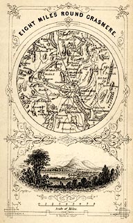
Map, uncoloured engraving, Eight Miles round Grasmere,
engraved by W Banks, Edinburgh, published by John Hudson,
Kendal, Westmorland, 1853.
Circular map, with a vignette view of Grasmere lake and Helm Crag below. Tipped in opp p.58 in A Complete Guide to the Lakes, edited John Hudson. |
||

|
Hudson 1842 map | |
| map feature:- | circular & vignettes & up is N & scale line & rivers & lakes & relief & hill hachuring & parks & parks & settlements & roads | |
| inscription:- |
printed top
EIGHT MILES ROUND GRASMERE. |
|
| inscription:- |
printed bottom
W. Banks, sc. Edinr. |
|
| wxh, sheet:- | 18x11cm | |