 Bowen 1773

|

|
|
|
item:- Armitt Library : Gents Mag 1773.1 image:- © see bottom of page |
click to enlarge |
|
|
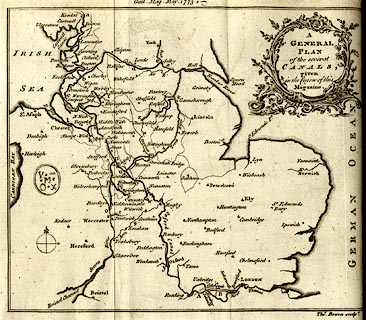
Map, uncoloured engraving, A General Plan of the Several
Canals given in the Course of this Magazine, engraved by
Thomas Bowen, published by the Gentleman's Magazine, 1773.
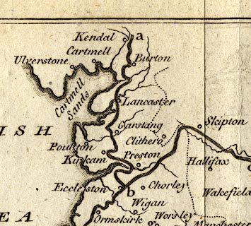
Tipped in opposite vol.43 p.221. The map includes England from Kendal in the north, St Asaph in the west, to just south of Reading. Descriptive text about the map is given pp.221-222, from which:- ' ... The extent of these canals could hardly have been thought practicable ar first setting out. Whoever had suggested the establishment of an inland navigation from Kendal, in Westmoreland, to London, before the taste for inland navigation became the mode, would have been looked upon as a visionary, and his undertaking would have been treated rather as the project of a madman, than the practicable idea of an able engineer: and yet, by the plan exhibited, it appears that the same has been, or will be soon, effected, without such an idea having ever entered into the minds of those by whom it either is, or will be completed. ...' 'Explanation of the Letters in the Plan. / a b mark the Lancaster Canal 72 1/2 [Miles] ...' |
||

|
Bowen 1773 | |
| map feature:- | baroque cartouche & compass rose & up is N & sea plain & coast form lines & rivers & county (some delimited) & settlements & canals | |
| inscription:- |
printed top
Gent. Mag. May 1773. |
|
| inscription:- |
printed upper right in baroque cartouche
A / GENERAL / PLAN / of the several CANALS / given / in the Course of this / Magazine |
|
| inscription:- |
printed bottom right
Thos. Bowen sculpt. |
|
| wxh, sheet:- | 25x21cm | |
| wxh, map:- | 205x174mm | |
|
||