 Unknown 1560s-90s

|

|
|
|
item:- private collection (130_3) image:- © see bottom of page |
click to enlarge |
|
|
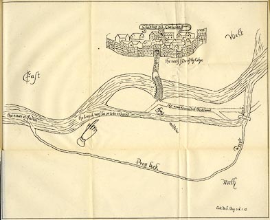
Map, lithograph, reproduction of Cotton MS Aug. vol.1.12,
Civitas Carliolen, the City of Carlisle, Cumberland, time of
Elizabeth I, published by Charles Thurnam and Sons,
Carlisle, Cumberland, Titus Wilson, Kendal, Westmorland, and
Elliot Stock, London, 1894.
The sketch map shows a breach in the bank of the River Eden flooding through The Sands to join the Priest Beck - 'the breach neces for ye to be repared'. pointed out by a hand. Reproduced from a copy used for a trial between the Corporation of Carlisle and the Duke of Devonshire about land rights, late 19th century. Tipped in oppposite p.100 of The Royal Charters of the City of Carlisle, edited by R S Ferguson. |
||

|
Unknown 1560s-90s | |
| map feature:- | folded (3x3) & banner cartouche & labelled borders & up is SW (roughly) & rivers & settlements & roads | |
| inscription:- |
printed cartouche over the city, at the top
Civitas Carliolen |
|
| wxh, sheet:- | 36x30.5cm | |
| wxh, map:- | 345x281mm | |